


HIGHLIGHTS
- Five wonderful daywalks through Tuscany’s idyllic mountains
- Challenging walks on certain weeks
- Stay in a beautifully situated Tuscan farmhouse with swimming pool
- Opportunity to visit Lucca on the free day
Itinerary
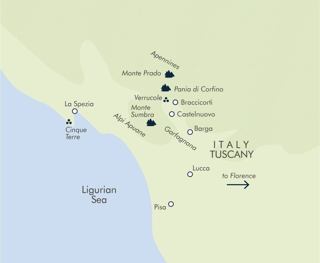
Start at Braccicorti lodge, approximately 6kms from Castelnuovo di Garfagnana and 2 hours from Pisa airport.
Day 2
After breakfast at Braccicorti we drive to the small village of Pruno where we begin our walk into the Orecchiella National Park, home to a variety of flora and fauna changing throughout the year. In spring it can be covered in snow when wolf, deer and mountain hare tracks are easily identifiable. Late spring and summer, the land is carpeted with an array of beautiful flowers and the beech trees begin to grow their iridescent lime green leaves which then change to deep oranges, browns and reds in the Autumn. If we are lucky we might spot a number of birds of prey; the common buzzard, the honey buzzard or one of the resident golden eagles. Set amongst the beautiful beech wood our walk steadily ascends to the flat summit of Pania di Corfino with its stunning 360 degrees views. After a leisurely picnic lunch we head to the 16th century village of Campaiana before following an ancient mule track which descends to the town of Corfino.
13km, total ascent: 603m, total descent: 603m, altitude maximum: 1603m.
Starting the day with a drive of approximately 40 minutes we arrive at the gorge of Fornovolasco in the Alpi Apuane NP. From here we follow the dry river bed through the woodland, before ascending more steeply to enjoy stunning views down to the Versilia coast and across to the famous marble quarries. We undertake a short scramble to meet the spine that leads up to the incredible rock arch of Monte Forato. The summit is only a stone’s throw away and should be ascended to enjoy the majestic views of Pania della Croce. Continuing on the path we descend sharply through the trees and past old shepherds huts to reach our minibus.
15km, total ascent: 693m, total descent: 693m, altitude maximum: 1223m.
Day 3
Today we drive 40 minutes to the small village of Vianova and begin our walk into the Alpi Apuane NP. Much of our initial ascent is on a wide forest track that continues through the beech wood to our first view point across to the face of Pania della Croce and the Omo Morto range. From here we take a footpath ascending to a limestone plateau where there is an optional ascent to the summit of Monte Sumbra (1765m). Weather permitting, we will enjoy an uninterrupted view of the Alpi Apuane range, the Ligurian coast and the enormous spine of the Apennines. After lunch on the summit we retrace our steps back to the limestone plateau, before heading down through the trees following one of the old charcoal trails back to the minibus. On the way back to Braccicorti, time permitting, we may stop in the lovely town of Careggine.
16km, total ascent: 672m, total descent: 672m, altitude maximum: 1765m.
Today we drive for around 45 minutes to return to the Alpi Apuane NP, this time to arrive at the foot of Uomo Morto, the ‘Dead Man’. We ascend steadily through beech wood to emerge at Rifugio Rossi, a small mountain hut at the foot of the ‘Dead Man’s’ nose! There is a high chance of seeing mouflon (wild mountain sheep) as we make our way up a large boulder field to a ridge that takes us to the top of the ‘Dead Man’s’ stomach and the summit of Pania della Croce at 1858m. Along with good views of the marble quarries and the local coastal town of Forte di Marmi below us, we can admire the coast to the Cinque Terre, the flat plains of Lucca and Pisa to the east and the long spine of the Apennine ridge on the opposite side of the valley. After a picnic lunch on the summit we retrace our steps back to the Rifugio, before heading back to the bus.
12km, total ascent: 758m, total descent: 758m, altitude maximum: 1858m.
Day 4
Having a change of guide for the day, we walk directly from the farmhouse at 410m, firstly visiting the new town of Villa Collemandina before heading to the church and learning about the history of the area. After this the route uses tracks, quiet lanes and footpaths through the local farmland and houses allowing us a real feel of local village life. Midway through the day we will arrive at Castiglione di Garfagnana at 545m, a small but beautiful mediaeval town, still inhabited and visited by tourists throughout the year. Castiglione is also the place where the region’s largest and most popular chestnut festival is held each autumn, celebrating the chestnut tree and the growth of truffles and mushrooms. After lunch we cross a 13th-century bridge below the town leading into more farmland and back to Braccicorti on easy tracks.
19km, total ascent: 145m, total descent: 145m, altitude maximum: 545m.
Changing guides for the day, today you transfer to 16th century shepherds village of Campocatino. From here you begin the continuous ascent on a well marked path to reach the ridge line of Monte Tambura where you will start your way unto the summit. The path can be a little exposed and loose in places with stunning views of the craggy peaks all around. From the summit you continue on the ridge line descending to one of the many marble quarries in this mountain range before carefully making your way across several small rocky sections with a fixed security line to aid you on your way back at Campocatino.
16km, total ascent: 800m, total descent: 800m, altitude maximum: 1890m.
Day 5
Free day to enjoy any of the following: 1 hr train journey to visit the stunning fortified city of Lucca; 20 minute taxi and 1.5 hr train journey to the coastal UNESCO World Heritage site of the Cinque Terre; 2.5 hr train journey to visit the capital city of Florence, home of Michelangelo’s David or the 1.5hr train journey to Pisa where you can ascend the leaning tower and walk along the beautiful river Arno.
There are also plenty of options closer to home. Relax with a good book at the farmhouse and make use of the sun loungers and outdoor pool, take a walk down to Lago di Pontecosi for lunch or take 10 minutes train along to Castelnuovo di Garfagnana for lunch and a walk to the old castle.
Day6
A drive of 25 minutes to Lago di Vagli with its submerged village and impressive backdrop of Monte Sumbra will bring us to the start point for the day; Vagli Sotto. From here we walk on a small footpath to the town of Vagli Sopra where we continue to ascend on a section of the pilgrimage walk through the chestnut wood to arrive at the 16th century shepherds village of Campocatino. Wandering through the village and seeing the beautiful terraced meadows, protected by the impressive wall of Roccandagia, it is easy to understand why the shepherds chose this location. From here we continue to our highest point for the day at 1190m before descending through the trees to San Viviano’s hermitage. Built into the rock face, the tiny hermitage is said to be where San Viviano lived before his bones were finally discovered in 1993. It is now used as a chapel and pilgrimage site. Our descent takes a rarely used mountain path with views across the valley before arriving back at the bus.
12.5km, total ascent: 630m, total descent: 630m, altitude maximum: 1190m.
After a 40 minute drive we begin our 2 day ridge walk with a steady ascent through the beech wood to meet the Crinali ridge in the Tosco-Emiliano Appennino NP. During the winter the ridge is covered in snow but spring brings the new growth of alpine flowers and autumn carpets the ground in purple hues from the myrtle berries mixed with the green juniper. Following the crest, this easy route takes us along the ridge up onto the summit of Monte Prado, the highest peak in Tuscany at 2054m. We then descend to the small tarn of Lago di Bargetana, before continuing into Emilia Romagna and up to Monte Cusna at 2121m. Marmots can be encountered on the way. After our second summit we descend to our mountain hut Rifugio Bargetana where we enjoy an evening meal before a well deserved rest. Nestled amongst the trees, the rifugio is known for its good food and wildlife spotting.
22.5km, total ascent: 807m, total descent: 807m, altitude maximum: 2121m.
Day 7
We start the day with a 40 minute drive to the small ski area of Casone. Walking through beech wood brings us to the beginning of the Crinali ridge, a section of the 1600km Apennine ridge in the Tosco/Emiliano/Apennino NP, offering some of the most impressive views of the week. Below is a basin of fiery colours from the forest between the ridge line of Tuscany and the opposite ridge of Emilia Romagna. Our route takes us along the undulating ridge on an easy path leading us up onto the peak of Monte Prado, the highest in Tuscany at 2054m. After lunch we retrace our steps along the ridge before descending on another route leading us through woodland back to Casone where there is a bar to enjoy a well earned drink.
16km, total ascent: 740m, total descent: 740m, altitude maximum: 2054m.
After our night in the mountain hut we retrace our steps to Lago di Bargetana, then head back into Tuscany and onto the Crinali ridge. We stay on this ridge line all day with fantastic views across the Alpi Apuane national park and the Serchio valley. During the autumn the views can stretch as far as the Alps to the North and the islands of Corsica and Sardinia. After completing 15km we arrive at Passo di Praderana where we will drive the 40 minutes to Braccicorti, with the option of stopping at the Osteria of Verrucole Fortress to enjoy a celebratory drink.
15km, total ascent: 209m, total descent: 209m, altitude maximum: 1949m.
Day 8
The trip ends at Braccicorti.
KEY INFORMATION
- 7 nights farmhouse with swimming pool
- 8 days land only/ flight inclusive
- 5 days centre-based walking; 1 free day
- Altitude maximum 2054m, average 1000m
- Challenging departures on selected weeks
- Countries visited: Italy
WHATS INCLUDED
- All breakfasts, 5 picnic lunches, 5 dinners
- All accommodation (see accommodation section)
- All transport and activities
- Tour leader throughout
- Flights from London (if booking incl. flights)
Images courtesy of Exodus Travel
EXT – TDT
Related experiences

Africa by Rail: Hosted Luxury Rovos Safari 2025 – Departs 28 August 2025
Tour Description Africa by Rail , a 10 day luxury Rovos Rail Safari, hosted by Rachel Williams – Founder and Adventure Guru from Viva Expeditions. Johannesburg to Victoria Falls, 28 August – 6 September 2025 Join us on an exclusive … Continue reading

Norfolk Island & NSW Including Sydney Harbour Cruise – Departs 20 February 2025
Tour Departs: 20 February 2025 Tour Length: 16 Days Price From: Share Twin NZD $11,700.00pp | Supplement for Single Room NZD $2,750.00pp | Total Cost for Single Room NZD $14,450.00pp Where history meets paradise, experience the “Norfolk Wave.” Explore lush forests, pristine beaches, … Continue reading

Japan in Autumn including Circle Japan Cruise – Departs 11 October 2024
Tour Departs: 11 October 2024 Tour Length: 27 Days We are venturing to Japan, Land of the Rising Sun, in time to enjoy the beginning of the autumn season. Autumn in Japan is about crimson leaves and perfect weather. As summer transitions … Continue reading

CROSSROADS OF THE CAUCASUS – Escorted Tour – Departs 04 May 2025
Small group hosted journey • Guaranteed to go • Flights included Introduction Discover the exotic history and culture of the Caucasus on this hosted journey through Istanbul, Georgia, Armenia and Azerbaijan. Explore the ancient birthplace of viticulture and wine-making in … Continue reading

Fabels of the Silk Road – 29 Days Escorted Tour – Departs 16 September 2025
Small group hosted journey • Guaranteed to go • Flights included Introduction Explore the cultural diversity and wonderful scenery of the ‘Five Stans’ of Central Asia. This varied landscape is home to traditional villages, ancient towns and glorious cities with … Continue reading

Mexico Unveiled – 24 Days Escorted Tour – Departing 27 October 2025
Introduction Immerse yourself in the vibrant tapestry of Mexico on this unforgettable journey. From the turquoise waters of the Maya Riviera to the ancient wonders of Teotihuacan, we’ll journey through history, culture, and breathtaking natural beauty. Explore Maya ruins kissed … Continue reading
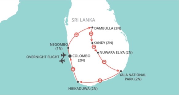
Highlights of Sri Lanka for Solo Travellers – 17 days Fully Inclusive Group Tour – Departing 22 November 2024
Departing 22 November 2024 Highlights of Sri Lanka for Solo Travellers Negombo (1N) – Sigiriya (3N) – Kandy (2N) – Nuwara Eliya (2N) – Yala National Park (2N) – Galle (2N) – Colombo (2N) From stunning scenery to amazing architecture, … Continue reading
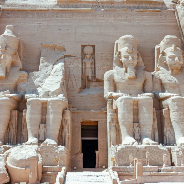
Petra to the Pyramids – Departing 24 October 2024
TWIN from NZ$22,598 per person, SINGLE from NZ$26,905 From floating in the Dead Sea more than 400 metres below sea level, to walking through the Siq for your first glimpse of the soaring facade of the Treasury at Petra. From … Continue reading
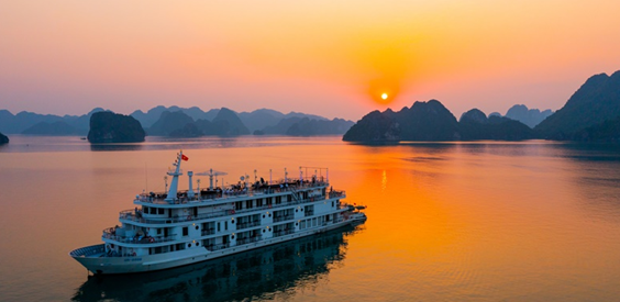
Escorted Tour to Vietnam & Cambodia with Anzac Memorials – Departing 01 April 2025
Historic Vietnam & Cambodia Exclusive Escorted Cruise & Land Tour – Auckland Return Tour Northern Vietnam, cruise the Mekong Delta, & visit ANZAC Memorials Escorted from NZ by Mark Nicholls of Mekong Princess Fly, Cruise & Land Tour Auckland – … Continue reading
Silk Road Odyssey – 29 Days Escorted Tour – 2 departures, departing Christchurch 03 & 10 May 2025
29 Day Small Group Escorted Tour 03 – 31 May 2025 & 10 May-7 June 2025 Escorted by Discover Travel’s Peter Dunne & Lyndon Hadden Tour price from $19,495 per person twin/double share* $22,995 per person in a single room* … Continue reading